Official Name:
特布德长城二边14段TeBuDeChangChengErBian14DuanOur Name:
/
Other Name:
/
Period:明 / Ming Dynasty 1368~1644
Location: 内蒙古自治区,鄂尔多斯市,鄂托克前旗,上海庙镇特布德嘎查西南5.7千米-西南8.6千米 / NeiMengGuZiZhiQu,EErDuoSiShi,ETuoKeQianQi,ShangHaiMiaoZhenTeBuDeGaChaXiNan57QianMiXiNan86QianMi
[
Looking Local List]
Details:长城类别:墙体
起点经纬高度:东经:106° 49′ 北纬:38° 9′ 海拔:1362
终点经纬高度:东经:106° 47′ 北纬:38° 10′ 海拔:1332
墙体走向:大致呈东-西走向,方向为西偏北约15°。
墙体类别:土墙
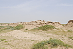
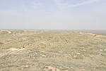
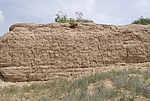
结构特点及构筑方式:该段墙体为人工基础,黄土夯筑,底宽上窄,向上有收分,剖面基本呈梯形。基宽5米-7米、顶宽0.5米-2米,夯层厚0.2米左右。由于破坏严重,墙体的设施情况不明。
现状:夯筑土墙。
Type:土墙 Rammed earth wall
Protection Level:无
Content:
Memo:
Other Records:
Distribution:
visit location in Tianditu Map[recommend] Distribution:
visit location in Tencent QQ Map Distribution:
visit location in Google MapDistribution:
visit location in Baidu MapNational ID:150623382101170026
Action:[
 Save in Data Basket
 ]
Picture:
Click the thumbnail to view the Big Pic. Click the Big Pic to Hide the Big Pic![Caption:特布德长城二边14段
loading images --Please wait...]()
![Caption:特布德长城二边14段
loading images --Please wait...]()
![Caption:特布德长城二边14段
loading images --Please wait...]() Photo Links
Photo Links:
 Search ::
  Favorite/My Favorite :: Recent Changes :: :: Login