Official Name:
ДҰҝЛМбДҫ·й»рМЁMoKeTiMuFengHuoTaiOur Name:
/
Other Name:
/
Period:МЖ / Tang Dynasty 618~907
Location: РВҪ®О¬Об¶ыЧФЦОЗш,ҝЛЦЭ,°ўНјКІКР,°ўНјКІКР°ўФъҝЛПзҝвДҫИшҝЛҙ嶫ДП20№«АпҙҰёкұЪМІЦР / XinJiangWeiWuErZiZhiQu,KeZhou,ATuShiShi,ATuShiShiAZhaKeXiangKuMuSaKeCunDongNan20GongLiChuGeBiTanZhong
ЎЎ[
Looking Local List]
Details:іӨіЗАаұрЈәөҘМеҪЁЦю
ҫӯОіёЯ¶ИЈә¶«ҫӯЈә076Ўг 29Ўд ұұОіЈә39Ўг 36Ўд әЈ°ОЈә1225
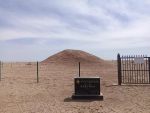
ҪЁЦюРОКҪЈә·й»рМЁХыМеТСМ®ЛъЎЈ
ІДБПЈәНБЕчАЭЖцЎЈ
ёҪҪьТЕҙжЈәОЮЎЈ
Type:·й»рМЁ Beacon Tower
Protection Level:ПШұЈЎЎ
Content:
ДҰҝЛМбДҫ·й»рМЁО»УЪ°ўФъҝЛХтҝвДҫИшҝЛҙеЈ¬ПЦҙжТЕЦ·ОӘТ»ЧщФІЗрРОНБЕч¶ХЈ¬УЙ№жёс35ЎБ35ЎБ10АеГЧөДНБЕчЖціЙЎЈ»щІҝЦұҫ¶15ГЧЈ¬ёЯ4ГЧЎЈөШұнҝЙјыЛйМХЖ¬әН¶ҜОп№ЗчАІРЖ¬ЎЈёщҫЭёГТЕЦ·ҪЁЦюМШөгіхІҪЕР¶ПЈ¬ҝЙДЬОӘ·й»рМЁЈ¬ДкҙъҝЙДЬОӘМЖЦБЛОҙъЎЈёГТЕЦ·ҙҰУЪІ©№ЕЧОҙпАыСЗәУ№ИәУҙІЙПЈ¬өШАнО»ЦГ·ЗіЈЦШТӘЈ¬¶ФСРҫҝёГөШЗшМЖЛОКұЖЪөДХюЦОЎўҫьКВЗйҝцУРТ»¶ЁөДІОҝјјЫЦө
Memo:
Other Records:
Distribution:
visit location in Tianditu Map[recommend] Distribution:
visit location in Tencent QQ Map Distribution:
visit location in Google MapDistribution:
visit location in Baidu MapNational ID:653001353201120009
The original number submitted by the local government Јә653001353201130009
(when the Great Wall is identified, the data whose code has been adjusted will display the original number submitted by the local government before revision, which can be used by the local cultural relics department when checking the local data.)
Action:[
 Save in Data Basket
 ]
Picture:
Click the thumbnail to view the Big Pic. Click the Big Pic to Hide the Big Pic![Caption:РВҪ®ҝЛЦЭДҰҝЛМбДҫ·й»рМЁ
loading images --Please wait...]() Photo Links
Photo Links:
ЎЎ Search ::
  Favorite/My Favorite :: Recent Changes :: :: Login