| [ Login ]/[ Register ] |
 Search ::
  My Data Basket ::
  Favorite/My Favorite :: Recent Changes :: :: Login Save in Data Basket ]
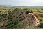
| Caption:杨二村长城4段 Photo Time:2007-07-22 18:37:57 Photo Contributor:陕西省文物局 [Open in New Window] |
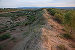
| Caption:杨二村长城4段 Photo Time:2007-07-22 19:30:41 Photo Contributor:陕西省文物局 [Open in New Window] |
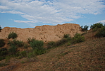
| Caption:杨二村长城4段 Photo Time:2007-07-22 18:20:28 Photo Contributor:陕西省文物局 [Open in New Window] |
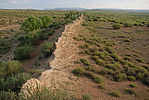
| Caption:杨二村长城4段 Photo Time:2007-07-22 18:55:42 Photo Contributor:陕西省文物局 [Open in New Window] |