| [ Login ]/[ Register ] |
 Search ::
  My Data Basket ::
  Favorite/My Favorite :: Recent Changes :: :: Login Save in Data Basket ]
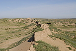
| Caption:特布德长城9段 Photo Time:2007-07-11 08:11:19 Photo Contributor:内蒙古自治区文物局 [Open in New Window] |
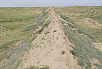
| Caption:特布德长城9段 Photo Time:2007-07-11 10:04:54 Photo Contributor:内蒙古自治区文物局 [Open in New Window] |
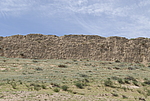
| Caption:特布德长城9段 Photo Time:2007-07-11 10:09:45 Photo Contributor:内蒙古自治区文物局 [Open in New Window] |
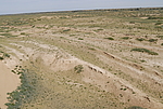
| Caption:特布德长城9段 Photo Time:2007-07-11 09:53:28 Photo Contributor:内蒙古自治区文物局 [Open in New Window] |