| [ Login ]/[ Register ] |
 Search ::
  My Data Basket ::
  Favorite/My Favorite :: Recent Changes :: :: Login Save in Data Basket ]
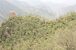
| Caption:口上村东侧敌台 Photo Time:2007-09-01 10:05:10 Photo Contributor:山西省文物局 [Open in New Window] |

| Caption:口上村东侧敌台 Photo Time:2007-09-01 11:54:48 Photo Contributor:山西省文物局 [Open in New Window] |
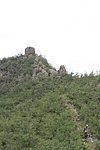
| Caption:口上村东侧敌台 Photo Time:2007-09-01 11:43:40 Photo Contributor:山西省文物局 [Open in New Window] |
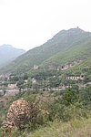
| Caption:口上村东侧敌台 Photo Time:2007-09-01 14:27:04 Photo Contributor:山西省文物局 [Open in New Window] |
| Caption:口上村东侧敌台 Photo Time:2007-09-02 10:00:57 Photo Contributor:山西省文物局 [Open in New Window] |